
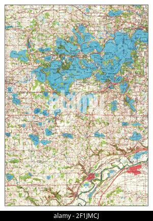

Antique Shakopee, Minnesota 1958 US Geological Survey Topographic Map – Scott, Carver, 2024 Hennepin County, Chanhassen, Eden Prairie, Jackson MN
Beautiful, antique map of Shakopee, Minnesota and surrounding Scott, Carver & Hennepin County areas. This is an authentic 1958 edition, 1973 print from the U.S. Geological Survey and NOT a computer reproduction.
See what Minnesota looked like over 60 years ago. Lots of intricate details and geological contours. Map even has little squares for every house that existed at the time. The USGS cartographers were very thorough back then!
Perfect for the historian, map-lover, the curious or just as a conversation starter. Wonderful and rare. Maps such as these make great gifts.
Edition of 1958, printed 1973
Dimensions: 22" width x 27" height
----
Features
Cities & Towns: Chanhassen, Eden Prairie, Jackson, Louisville, Eagle Creek, Hazeltine, Chaska, 2024 Carver.
Points of Interest: Lake Minnewashta, Lake Ann, Lotus Lake, Hazeltine Lake, Lake Riley, Rice Lake, Chaska Lake, Gifford Lake, Nyssens Lake, Minnesota River, Riley Creek, Bluff Creek, and many more hills, streams, ponds, houses, schools, railroads, churches and roads.
Condition: Good Vintage condition, commensurate with age. This map is in great shape for being over 45 years old. Has folds as issued but will flatten easily and will read as character when framed.
----
We will happily adjust shipping price for multiple purchases. Map will be shipped folded to preserve integrity.